

Gellaig Ridge


Key information: Gellaig Ridge 
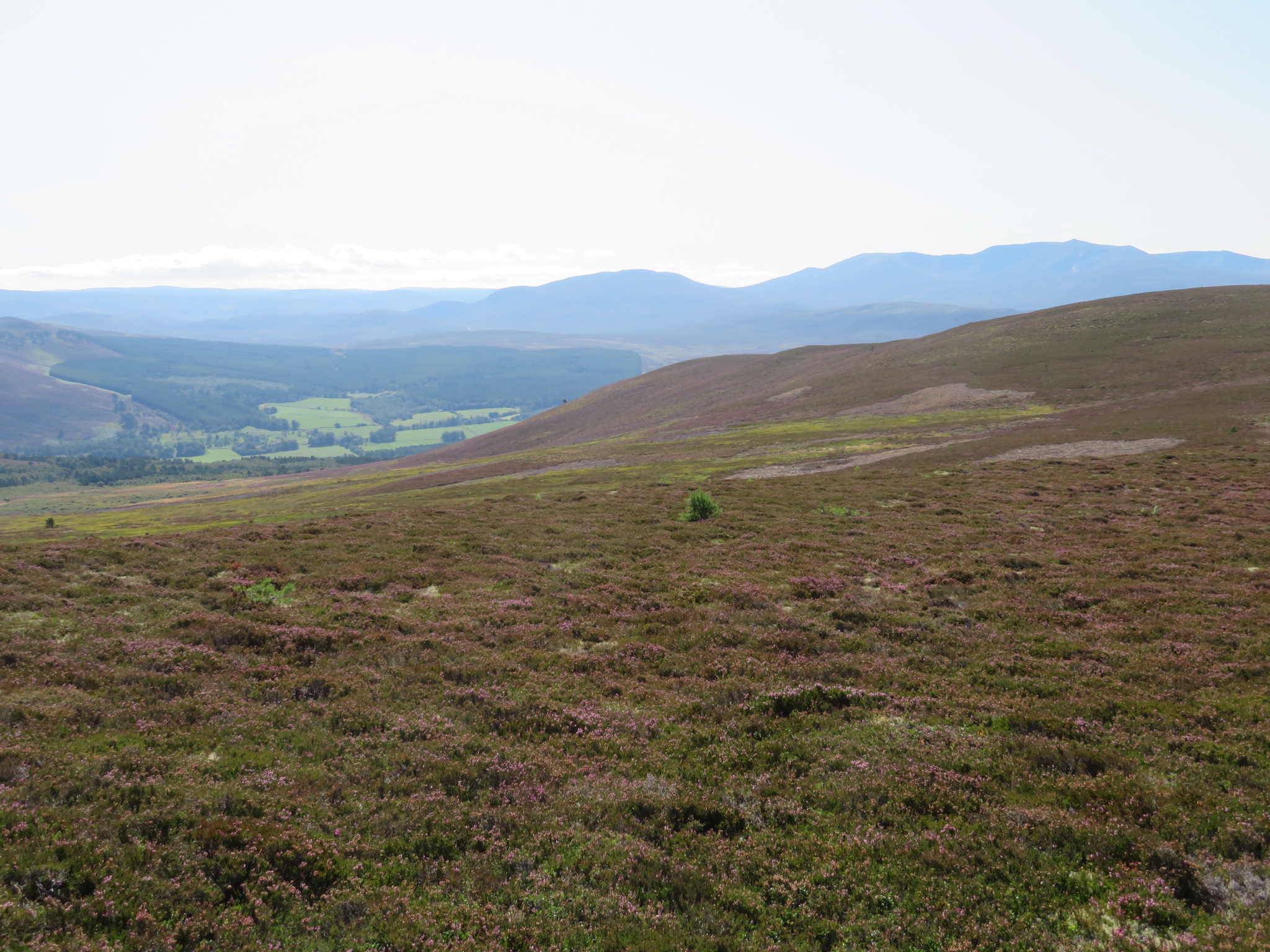
- Long heathery ridge above the mid Dee which boasts some of the best views in the Cairngorms.
Walkopedia rating
- Walkopedia rating87.5
- Beauty31
- Natural interest15
- Human interest10
- Charisma31.5
- Negative points0
- Total rating87.5
Vital Statistics
- Length: Your choice
- Maximum Altitude: 743m
- Level of Difficulty: Variable

WALK SUMMARY
The long, relatively gentle, heathery Gellaig ridge (high point, 743m) north of the Dee west of Ballater boasts, in our view, some of the best views in the Cairngorms: south to the dark drama of Lochnagar's line of vast cliffs, and west up the Dee valley past Balmoral to ridge after receding ridge of mountains; north across the beautiful bowl of the Gairn, which retreats into the roadless wilds of the central Cairngorms, with the great corries of Ben a Bhuird and the huge landmark tor of Ben Avon on the skyline. Eastwards, you gaze straight down the Dee towards the sea; and south-east, Mount Keen's elegant pyramid dominates the skyline of the South Deeside hills.
This is an unheralded delight: like so many amazing walks here, it is not in any book or website - we just thought it looked promising on the map.
The ridge is accessed by 3 tracks from the magnificent C18 military road to the north, which was built after the '45 rebellion to help suppress the Highlands. Ie, you can make combinations of walks to suit your circs. A marvellous slow 3 hrs if making a shorter circuit.
SEE OUR CAIRNGORMS PAGE FOR FURTHER INFORMATION (INCLUDING PRACTICALITIES) ON AND OTHER GREAT WALKS IN THE AREA.
Other accounts: share your experiences
Your comments on this walk, your experiences and suggestions, and your photos are very welcome. Where appropriate, you will be credited for your contribution.

Safety and problems: All walks have inherent risks and potential problems, and many of the walks featured on this website involve significant risks, dangers and problems. Problems of any sort can arise on any walk. This website does not purport to identify any (or all) actual or potential risks, dangers and problems that may relate to any particular walk.
Any person who is considering undertaking this walk should do careful research and make their own assessment of the risks, dangers and possible problems involved. They should also go to “Important information” for further important information.

Anyone planning an expedition to this place should see further important information about this walk.

Responsible travel matters, a lot. How you travel will make a real difference - for better or worse. PLEASE consider this when making plans. Read more
Contents
Other great walks in United Kingdom
-
Beinn a Bhuird
-
Ben Avon
-
Ben Macdui
-
Cairn Gorm
-
Cairn Toul and Braeriach
-
Capel Mounth Track
-
Carn a'Mhaim
-
Gellaig Ridge
-
Glen Callater
-
Glen Gairn
-
Glen Lui
-
Head of the Don Valley
-
Lairig Ghru
-
Lochnagar and Loch Muick
-
Muir of Dinnet (Loch Kinord and Burn O'Vat)
-
Sron Riach ridge to Ben Macdui
-
The Cairngorms
-
Tolmount /Jock's Road
-
Upper Dee Valley
-
England, Blenheim Park
-
England, Epping Forest
-
England, Oxford Kora (Martin's Trail)
-
England, Stowe Gardens
-
England, Thames Path
-
England, The Ridgeway
-
England, The Whittington Way
-
England, Cotswolds, Cotswold Way
-
England, Cotswolds, Diamond Way
-
England, East Anglia, Anna's Walk
-
England, Hadrian's Wall, Cawfields to Birdoswald
-
England, Hadrian's Wall, Sewingshields to Cawfields
-
England, Lake District, Blencathra / Saddleback
-
England, Lake District, Catbells and High Spy
-
England, Lake District, Coast to Coast across Lake District
-
England, Lake District, Cumbria Way and High Way
-
England, Lake District, Grasmere / Far Easedale
-
England, Lake District, Great Gable
-
England, Lake District, Hay Stacks /High Stile Ridge
-
England, Lake District, Helvellyn and Striding Edge
-
England, Lake District, High Street
-
England, Lake District, Langdale Pikes
-
England, Lake District, Langdale Valleys
-
England, Lake District, Martindale
-
England, Lake District, Pavey Ark via Jack's Rake
-
England, Lake District, Pillar
-
England, Lake District, Scafell Pike
-
England, Lake District, Skiddaw
-
England, Lake District, Swirl How and Great Carrs
-
England, Lake District, The Old Man of Coniston
-
England, North, Cleveland Way
-
England, North, Coast to Coast
-
England, North, Durham Heritage Coastal Path
-
England, North, Pennine Way
-
England, South, Box Hill
-
England, South, South Downs Way
-
England, South, Tennyson Trail, Isle of Wight
-
England, South, The Pilgrim's Way
-
England, South, Winnall Moors
-
England, South-west, Jurassic Coast
-
England, South-west, Lundy Island
-
England, South-west, South West Coast Path
-
England, South-west, Two Moors Way
-
England, South-west, Weymouth to Kimmeridge
-
England, South-west, Exmoor, Barle Valley
-
England, South-west, Exmoor, Dunkery Beacon
-
England, South-west, Exmoor, Exmoor
-
England, South-west, Exmoor, North Devon Coastal Path
-
England, West, Malvern Hills
-
England, Yorkshire Dales, Dales Way
-
England, Yorkshire Dales, Feizor Thwait and Smearsett Scar
-
England, Yorkshire Dales, Ingleborough
-
England, Yorkshire Dales, Malham Cove and Gordale Scar
-
England, Yorkshire Dales, Sleddale and Wether Fell
-
England, Yorkshire Dales, Wensleydale
-
England, Yorkshire Dales, Yorkshire Dales
-
England/Wales, Offa's Dyke Path
-
Northern Ireland, Mountains of Mome
-
Northern Ireland, Causeway Coast, Causeway Coast Way
-
Northern Ireland, Causeway Coast, Portstewart to Portballintrae
-
Scotland, Edinburgh
-
Scotland, Great Glen Way
-
Scotland, Stalking
-
Scotland, Aberdeenshire, Bennachie
-
Scotland, Aberdeenshire, Dunottar
-
Scotland, Borders, Eildon Hills
-
Scotland, Borders, Southern Uplands Way
-
Scotland, Borders, St Abbs Head
-
Scotland, Borders, St Cuthbert's Way
-
Scotland, Borders, The Borders
-
Scotland, Isles, Mull, Iona
-
Scotland, Isles, Skye, Bla Bheinn
-
Scotland, Isles, Skye, Black Cuillin Ridge
-
Scotland, Isles, Skye, Bruach na Frithe
-
Scotland, Isles, Skye, Camasunary and the Elgol Peninsula
-
Scotland, Isles, Skye, Coire Lagan and Sgurr Alasdair
-
Scotland, Isles, Skye, Coire na Creiche
-
Scotland, Isles, Skye, Coral Beach
-
Scotland, Isles, Skye, Eastern Red Cuillin Circuit
-
Scotland, Isles, Skye, Glen Sligachan
-
Scotland, Isles, Skye, Loch Coruisk
-
Scotland, Isles, Skye, NW Capes and Cliffs
-
Scotland, Isles, Skye, Quiraing
-
Scotland, Isles, Skye, Raasay
-
Scotland, Isles, Skye, Rhub an Dunain
-
Scotland, Isles, Skye, Rubha Hunish
-
Scotland, Isles, Skye, Sgurr Dearg and Inaccessible Pinnacle
-
Scotland, Isles, Skye, Sgurr na Stri
-
Scotland, Isles, Skye, Sgurr nan Gillean
-
Scotland, Isles, Skye, Skye Trail
-
Scotland, Isles, Skye, Strath Mor and Strath Beag
-
Scotland, NW Highlands, Beinn Eighe
-
Scotland, NW Highlands, Ben Stack
-
Scotland, NW Highlands, Ardnamurchan, Silver Walk
-
Scotland, NW Highlands, Ardnamurchan, Ardnamurchan Area
-
Scotland, NW Highlands, Ardnamurchan, Beinn Resipol
-
Scotland, NW Highlands, Ardnamurchan, Ben Hiant
-
Scotland, NW Highlands, Ardnamurchan, Garbh Bheinn of Ardgour
-
Scotland, NW Highlands, Assynt, Achmelvick Bay
-
Scotland, NW Highlands, Assynt, Stac Pollaidh
-
Scotland, NW Highlands, Assynt, Suilven
-
Scotland, NW Highlands, Knoydart, Inverie to Glenfinnan
-
Scotland, Orkney Islands, Hunda Reef, Burra
-
Scotland, Orkney Islands, Marwick Head
-
Scotland, Orkney Islands, Mull Head, Deerness
-
Scotland, Orkney Islands, North-west Coast, Westray
-
Scotland, Orkney Islands, Orkney Islands
-
Scotland, Orkney Islands, Skara Brae to Stromness
-
Scotland, Orkney Islands, The Old Man and St John's Head, Hoy
-
Scotland, SW Highlands, Ben Nevis
-
Scotland, SW Highlands, Bridge of Orchy to Kingshouse, Rannoch Moor
-
Scotland, SW Highlands, Kingshouse to Kinlochleven
-
Scotland, SW Highlands, Kinlochleven to Fort William
-
Scotland, SW Highlands, Upper Glen Nevis
-
Scotland, SW Highlands, West Highland Way
-
Wales, Ceredigion Coastal Path
-
Wales, Craig Cefn Parc
-
Wales, Black Mountains, Black Hill Ridge
-
Wales, Black Mountains, Black Mountains
-
Wales, Black Mountains, Castell Dinas and Rhiangoll Valley
-
Wales, Black Mountains, Crug Hywel
-
Wales, Black Mountains, Hatterrall Ridge
-
Wales, Black Mountains, Skirrid Fawr
-
Wales, Black Mountains, Sugarloaf
-
Wales, Brecon Beacons, Brecon Beacons
-
Wales, Brecon Beacons, Fforest Fawr
-
Wales, Brecon Beacons, Pen Y Fan
-
Wales, Brecon Beacons, The Beacons Way
-
Wales, Brecon Beacons, The Black Mountain
-
Wales, Pembrokeshire, Pembrokeshire Coast Path
-
Wales, Pembrokeshire, The Golden Road, Preseli Hills, Pembrokeshire
-
Wales, Snowdonia, Bala Lake
-
Wales, Snowdonia, Cadair Idris
-
Wales, Snowdonia, Carneddau
-
Wales, Snowdonia, Carneddau from the South
-
Wales, Snowdonia, Crib Goch Ridge
-
Wales, Snowdonia, Glyderau
-
Wales, Snowdonia, Glyderau from Pen-y-Pass
-
Wales, Snowdonia, Mawddach/Dolgeallau Area
-
Wales, Snowdonia, Miners, Pyg Tracks
-
Wales, Snowdonia, Mount Snowdon
-
Wales, Snowdonia, Nantlle Ridge
-
Wales, Snowdonia, Snowdon Horseshoe
-
Wales, Snowdonia, Tryfan
-
Wales, Snowdonia, Watkin and Rhyd Ddu paths
-
Wales, Snowdonia, Y Lliwedd
RESEARCH ESSENTIALS
Information and review
Finding flights, organising travel
Car hire
Accommodation
- Booking.com
 Search and book the best places to stay
 -
TripAdvisor
Equipment & Clothing
Books and Maps
- Amazon
- Maps and guides from Maps Worldwide
- Cicerone � explore the world�s best collection of walking books
Holidays and Activities

MAGAZINE

Walking with Trees: the Kumano Kōdō Kōhechi - Stephen Barber's account and photos of one of Japan's great pilgrimage trails. March 2021
RESPONSIBLE TRAVEL
Responsible travel matters, a lot. How you travel will make a real difference - for better or worse. PLEASE consider this when making plans. Read more