


The Needles


Key information: The Needles 
- This area of extraordinary sandstone towers, spires, needles (even) and arches laced with canyons big and small and scrubby pockets contains some thrilling and very varied walking.
- Not to be missed if in Canyonlands.
Walkopedia rating
- Walkopedia rating89
- Beauty33
- Natural interest18
- Human interest2
- Charisma36
- Negative points0
- Total rating89
Vital Statistics
- Length: Variable
- Level of Difficulty: Variable

WALK SUMMARY
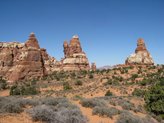
This big area in the south-west of Canyonlands National Park consists at its heart of extraordinary – even weird at times – brightly coloured sandstone towers, spires, needles (even), mushrooms, cliffs and walls and arches laced with canyons big and small and scrubby pockets, and sheltering the area of dry grassland known as Chesler Park. The Needles have been shaped by the erosion of a multitude of vertical fractures.
From a distance, the Needles look like a solid rampart of towers and spires, but this is deceptive: they are riddled with paths.
Around the core of “needles” are eroded slickrock and shallow canyons, which themselves support some fine walking.
The whole area is a bit of a maze, and it is hard to explain the walking in it, but here goes.
Access is by a long road in from the east, from the main 191 Interstate south of Moab. It is 30+ mins to the visitor centre. The main Needles group lies to the south-west of this, the drop-off to the inner Colorado canyon to the west, and rough slickrock to the north-west.
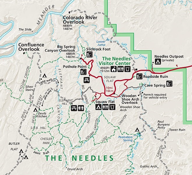
There are some 4x4 routes to the sides of the central Needles, but these, including the route to Elephant Hill, require passes for access as of writing – check the latest. So, for many, hiking in from the roadhead is the only ‘day’ option, and this means you can either make short explorations on the fringes of the Needles, or longer hikes into the heart.
In the south-west is the peculiar, unexpected area of dry grassland surrounded by extraordinary needly formations known as Chesler Park, many would argue the area’s finest walking, which takes some getting to, but is accessible in some 3 miles’ hiking from Elephant Hill, or 1.4 miles from the Devil’s Kitchen campground, if you have a 4x4 (and pass); 4+ miles from Squaw Flat if not. (For many, the best way to explore the area is therefore to backpack in and camp for a night or two, giving time for local exploration without the long walks in/out.)
There is consensus that the best walk is the Chesler Park Loop/Joint Trail, a 11 mile (18km) circuit of Chesler Park from/to Elephant Hill (6miles appx if already in Chesler Park), which gets to admire the local rocky peculiarities, including the exceptional, even by local standards, formations and rocky psychedelia of Elephant Canyon on the way in, and sweeping views of the Needles. The dramatic Joint Trail section creeps through very narrow, deep gaps in the formations. If you don’t have time to walk the whole way in to Chesler Park there is a superb 6 mile there-and-back to Chesler Park Viewpoint.
(Walkopedia regrets not having time when we visited to get out to Chesler Park.)
Other great walks within the main Needles area:
There is a fine 4 mile (return) walk further out from Chesler Park to the elevated Druid Arch to the south. It is 10 miles return from Elephant Hill (even further from Squaw Flat), passing through magnificent Elephant Canyon.
Big Spring Canyon to Squaw Canyon, a magnificent 7.5 mile loop from squaw Flat, steep at times but with excellent views of the Needles. Could extend to Lost Canyon.
Big Spring Canyon to Elephant Canyon. Just under 11 miles, demanding, but remarkable views of canyons and formations, from slickrock and mesa tops.
Squaw Canyon to Lost Canyon, an at times demanding but superb 10 mile loop.
Peekaboo: Squaw Flat to Salk Creek Canyon, crossing the upper ends of Squaw and Lost canyons and making high slickrock traverses with some exposure.
Outside the main Needles area, there is further magnificent walking:
The Confluence Outlook Trail runs west from the northern roadhead to a superb high lookout over the… er…confluence of the Colorado and Green rivers. This is a more standard hike than those within the Needles, through bigger, more open country. 16km/10 miles +.
The Slickrock Trail meanders for 4 km or so through the rough bare rock of the north of the area, winding to an overlook across the low Little Spring Canyon, then across to the deeper Big Spring one. An interesting walk on rough but not difficult slickrock; good views to the wall of the needles, fine ones to the further Island in the Sky, which dominates the western horizon. Worthwhile if not amazing walk.
As a specimen of the area’s astonishing walking opportunities, Walkopedia walked a Circuit above Squaw Flats Roadhead: This trail leaves Squaw Flat road-end carpark on the route to (The Squaw Canyon and Peekaboo trails, turning off quite soon to the right, and circling back across the top of the local sandstone formation, a ridge of flat tops, knobs and sheer sides. The way is marked by small cairns. An exciting trail with some easy scrambles. Good views across Squaw Flats and over a meadowy rock-enclosure to the Needles rampart, through which the Big Springs Canyon Trail departs. (2 miles, 1hr + without stops.)
Hike gorgeous Upper Salt Creek Canyon to the east, through fabulous scenery, including the famous Angel Arch, and taking in old Indian ruins and rock art.
Walkopedia was very short of time, and walked the Slickrock Trail and the Circuit above Squaw Flats Roadhead. We wish we had had time to get to Chesler Park.
This can be tough walking in hot, dry conditions. Come fully prepared, including carrying plenty of water.
Find relevant books on Amazon.
See our Canyonlands National Park page for more general and practical information and photos.
Other accounts: share your experiences
Your comments on this walk, your experiences and suggestions, and your photos are very welcome. Where appropriate, you will be credited for your contribution.

Safety and problems: All walks have inherent risks and potential problems, and many of the walks featured on this website involve significant risks, dangers and problems. Problems of any sort can arise on any walk. This website does not purport to identify any (or all) actual or potential risks, dangers and problems that may relate to any particular walk.
Any person who is considering undertaking this walk should do careful research and make their own assessment of the risks, dangers and possible problems involved. They should also go to “Important information” for further important information.

Anyone planning an expedition to this place should see further important information about this walk.

Responsible travel matters, a lot. How you travel will make a real difference - for better or worse. PLEASE consider this when making plans. Read more
Contents
Other great walks in USA
-
Continental Divide Trail
-
Alaska, Kenai Peninsula
-
Alaska, McGonagall Pass
-
California, Californian Redwoods
-
California, John Muir Trail
-
California, Mount Whitney
-
California, Pacific Crest Trail
-
California, San Francisco Bay Trail
-
California, Tahoe Rim Trail
-
California, Yosemite, El Capitan
-
California, Yosemite, Four Mile Trail
-
California, Yosemite, Grand Traverse
-
California, Yosemite, Half Dome
-
California, Yosemite, Hetch Hetchy Area
-
California, Yosemite, Mist Trail
-
California, Yosemite, North Dome
-
California, Yosemite, Off Glacier Point Road
-
California, Yosemite, Off Tioga Road
-
California, Yosemite, Panorama Trail
-
California, Yosemite, Pohono Trail
-
California, Yosemite, Sentinel Dome and Taft Point
-
California, Yosemite, Sunrise Lakes and Clouds Rest
-
California, Yosemite, Tuolunme Meadows Area
-
California, Yosemite, Yosemite Falls
-
Eastern, Appalachian Trail
-
Eastern, Gettysburg
-
Eastern, Stony Man Trail, Shenandoah NP
-
Hawaii, Haleakala National Park
-
Hawaii, Kalalau Trail, Kauai
-
Hawaii, Mt Kilauea
-
Mid-west, Black Hills and Grasslands, South Dakota
-
Mid-west, Matthiessen State Park
-
Mid-west, Sleeping Bear Dunes, Michigan
-
Mid-west, Superior Hiking Trail
-
North-east, Breakneck Ridge Trail
-
North-east, Brooklyn Bridge, New York
-
North-east, Finger Lakes Trail
-
North-east, Freedom Trail, Boston
-
North-east, Long Trail, Vermont
-
North-east, The Devil's Path, Catskill Mountains
-
North-west, Crater Lake
-
North-west, Great Basin Divide, Wyoming
-
North-west, Icicle Ridge
-
North-west, Mt Rainier
-
North-west, Mt St Helens
-
North-west, Sawtooth Mountains/Traverse
-
North-west/Cascades, The Enchantments
-
North-west/Olympic NP, Bogachiel River Valley
-
North-west/Olympic NP, Hoh River Trail
-
North-west/Olympic NP, Lake Crescent Area
-
North-west/Olympic NP, North Wilderness Coast
-
North-west/Olympic NP, Olympic Discovery Trail
-
North-west/Olympic NP, Olympic National Park
-
North-west/Olympic NP, Queets River Valley
-
North-west/Olympic NP, Quinault River Valley
-
North-west/Olympic NP, Second Beach
-
North-west/Olympic NP, Shipwreck Coast
-
North-west/Olympic NP, Sol Duc River Valley
-
North-west/Olympic NP, The High Divide Loop
-
South, Freedom Marches
-
South, Mount le Conte
-
South: Great Smoky Mountains NP, Great Smoky Mountains National Park
-
South-west, Canyon de Chelly
-
South-west, Goblin Valley, Utah
-
South-west, Grand Gulch, Utah
-
South-west, Monument Valley, Utah
-
South-west, Sedona
-
SW: Arches NP, Arches National Park
-
SW: Arches NP, Delicate Arch
-
SW: Arches NP, Devil's Garden and Primitive Loop
-
SW: Bryce Canyon, Bryce Canyon
-
SW: Bryce Canyon, Fairyland Loop
-
SW: Bryce Canyon, Navajo Loop
-
SW: Bryce Canyon, Peekaboo Trail
-
SW: Bryce Canyon, Queen's Garden Trails
-
SW: Capitol Reef, Capitol Reef
-
SW: Capitol Reef, Hickman Rock Bridge
-
SW: Capitol Reef, Rim Overlook and Navajo Knobs
-
SW: Grand Canyon, Bright Angel Trail
-
SW: Grand Canyon, Crossing the Canyon
-
SW: Grand Canyon, Grand Day Loop
-
SW: Grand Canyon, Havasu Canyon
-
SW: Grand Canyon, North Kaibab Trail
-
SW: Grand Canyon, Rim Trails
-
SW: Grand Canyon, South Kaibab Trail
-
SW: Grand Canyon, Thunder River, Deer Creek Trails
-
SW: Grand Canyon, Tonto Trail
-
SW: Grand Staircase-Escalante, Grand Staircase-Escalante Nat Monument
-
SW: Grand Staircase-Escalante, Willis Creek
-
SW: Vermilion Cliffs, Buckskin Gulch and Paria Canyon
-
SW: Vermilion Cliffs, The Wave
-
SW: Vermilion Cliffs, Vermillion Cliffs, Coyote Buttes
-
SW: Zion, Angel's Landing
-
SW: Zion, East Rim and East Rim Summits Trails
-
SW: Zion, Observation Point and Hidden Canyon
-
SW: Zion, The Subway/Left Fork
-
SW: Zion, West Rim Trail
-
SW: Zion, Wildcat Canyon and Northgate Peaks
-
SW: Zion, Zion Narrows
-
SW: Zion, Zion National Park
-
Texas, Kennedy Assassination Site, Dallas
-
Western, Lewis and Clark National Trail
-
Western, Maroon Bells
-
Western, Mounts Elbert and Massive
-
Western/Rocky Mountain NP, Bear Lake to Fern Lake
-
Western/Rocky Mountain NP, Glacier Gorge
-
Western/Rocky Mountain NP, James Peak/Indian Peak Wilderness Area
-
Western/Rocky Mountain NP, Longs Peak
-
Western/Rocky Mountain NP, Odessa Lake
-
Western/Rocky Mountain NP, Rocky Mountain NP
-
Western: Bitterroot Mts, Bitterroot Mountains
-
Western: Bitterroot Mts, Trapper Peak
-
Western: Bob Marshall Wilderness, Bob Marshall Wilderness
-
Western: Bob Marshall Wilderness, Chinese Wall
-
Western: Bob Marshall Wilderness, Upper Holland Loop
-
Western: Glacier NP, Glacier National Park
-
Western: Glacier NP, Grinnell Glacier Trail
-
Western: Glacier NP, Iceberg Lake Trail
-
Western: Glacier NP, North Circle
-
Western: Grand Teton NP, Garnet Canyon
-
Western: Grand Teton NP, Grand Teton Loop
-
Western: Grand Teton NP, Jenny Lake to Cascade Canyon
-
Western: Grand Teton NP, Paintbrush/Cascade Loop
-
Western: Grand Teton NP, Teton Crest Trail
-
Western: Grand Teton NP, Two Ocean Trail/Emma Matilda Lake
-
Western: Wind River Mts, Cirque of the Towers
-
Western: Wind River Mts, Deep Lake Cirque
-
Western: Wind River Mts, Highline Trail
-
Western: Wind River Mts, Titcomb Basin
-
Western: Wind River Mts, Wind River Mountains
-
Western: Yellowstone NP, Bechler River and Canyon
-
Western: Yellowstone NP, Black Canyon Trail
-
Western: Yellowstone NP, Geyser Area Trails
-
Western: Yellowstone NP, Mount Washburn
-
Western: Yellowstone NP, The Thorofare Trail
-
Western: Yellowstone NP, Uncle Tom's Trail
-
Western: Yellowstone NP, Yellowstone NP, Wyoming
RESEARCH ESSENTIALS
Information and review
Finding flights, organising travel
Car hire
Accommodation
- Booking.com
 Search and book the best places to stay
 -
TripAdvisor
Equipment & Clothing
Books and Maps
- Amazon
- Maps and guides from Maps Worldwide
- Cicerone � explore the world�s best collection of walking books
Holidays and Activities

MAGAZINE

Walking with Trees: the Kumano Kōdō Kōhechi - Stephen Barber's account and photos of one of Japan's great pilgrimage trails. March 2021
RESPONSIBLE TRAVEL
Responsible travel matters, a lot. How you travel will make a real difference - for better or worse. PLEASE consider this when making plans. Read more