


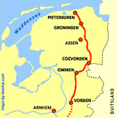
Pieterpad


Key information: Pieterpad 
- A long north-south route in the east of the Netherlands, through a wide variety of landscapes.
Walkopedia rating
- Walkopedia rating83
- Beauty29
- Natural interest13
- Human interest12
- Charisma29
- Negative points0
- Total rating83
Vital Statistics
- Length: 492km
- Level of Difficulty: Moderate

WALK SUMMARY
A long north-south route in the east of the Netherlands, through a wide variety of landscapes from the flat and low and to gently rolling wood and pasture. One of the first long-distane walking routes in the Netherlands.
Walkopedia friend Muntjewerf says:
"A 492 kilometers long route along the borders of the Netherlands and Germany. You see all kinds of landscapes pass, as you walk from Maastricht (Saint Pieter "mountain") to Pieterburen (at the Waddensea)or the other way around.
Information about this path is mainly available in the Dutch language (www.pieterpad.nl). But the path is very well marked with red-white markers. In Holland it's not allowed to stay camping freestyle in the woods. But we walked the whole route (and some parts twice)without problem. We camped out all the time (in the wintertime) and never ever anybody send us away or fined us. On the contrary,several times people offered us a free stay on their premises.
It's a different way of walking, as you walk true inhabited areas on a daily basis. Really in the middle of nowhere you'll only be on certain stretches of the route. But it's a fine way of getting to know the Dutch (and some German) countryside and the people that live there!"
Walkopedia says THANK YOU! Thanks you also to Marjin Bosma for the maps.
Any more thoughts, or pictures, out there, community?
Other accounts: share your experiences
Your comments on this walk, your experiences and suggestions, and your photos are very welcome. Where appropriate, you will be credited for your contribution.
 - © Flickr user ritzotencate")
Safety and problems: All walks have inherent risks and potential problems, and many of the walks featured on this website involve significant risks, dangers and problems. Problems of any sort can arise on any walk. This website does not purport to identify any (or all) actual or potential risks, dangers and problems that may relate to any particular walk.
Any person who is considering undertaking this walk should do careful research and make their own assessment of the risks, dangers and possible problems involved. They should also go to “Important information” for further important information.
COMMUNITY COMMENTS AND PHOTOS
Name: Carmenom
Posted on: 10/09/2018
I walked the Pieterpad 2016, 2017, and 2018 in three segments of approximately 100mi/160kl each. I covered half of each segment with a friend and half by myself. It is an easy, flat, and well-maintained trail. You pass through farmlands, wetlands, forests, villages, and cities. You are rarely very far from a town or city; the scenery is lovely as are many of the older towns, the country manor houses, and the windmills. It is satisfying to become acquainted with a country by walking its length. The trail is the most popular in the country but never felt crowded. I stayed in a B&B or small hotel each night, all arranged ahead of time through a Dutch travel agency. There are occasional unstaffed rest places along the way, signposted RUST (it means peace and perhaps rest), which are small rooms off a school, office, or home. They were originally set up for cyclists, but welcome walkers too. They have snack foods and drinks sold on an honor system, a place to sit and eat or rest, and a bathroom. There’s also a network of inexpensive places, again originally for cyclists, to spend the night but I’m not sure of the name of the organization that prints and distributes the directory.
Walko says THANK YOU for these helpful thoughts!
 - © Flickr user Ritzo ten Cate")
Anyone planning an expedition to this place should see further important information about this walk.

Responsible travel matters, a lot. How you travel will make a real difference - for better or worse. PLEASE consider this when making plans. Read more
Other great walks in Netherlands
RESEARCH ESSENTIALS
Information and review
Finding flights, organising travel
Car hire
Accommodation
- Booking.com
 Search and book the best places to stay
 -
TripAdvisor
Equipment & Clothing
Books and Maps
- Amazon
- Maps and guides from Maps Worldwide
- Cicerone � explore the world�s best collection of walking books
Holidays and Activities

MAGAZINE

Walking with Trees: the Kumano Kōdō Kōhechi - Stephen Barber's account and photos of one of Japan's great pilgrimage trails. March 2021
RESPONSIBLE TRAVEL
Responsible travel matters, a lot. How you travel will make a real difference - for better or worse. PLEASE consider this when making plans. Read more