


Mount Kailash Kora
Quick links
- Length: 53 km
- 2-3 days
- Maximum Altitude: 5,630m
- Level of Difficulty: Very Difficult
Walkopedia rating
Beauty
|
35 |
Natural interest |
16 |
Human interest
|
18 |
Charisma |
38 |
Negative points |
(7) |
Total rating |
100 |
| Note: Neg: severe altitude. | |
Tibet, China
Key information
-
Pilgrimage walk around Tibet's most sacred mountain.
-
Extraordinary glacial scenery, views of this superb 6,700m peak.
-
Deep spiritual significance: the company of pilgrims from all over Tibet and further afield. (You are seldom in empty landscape.)
-
This walk is high (crossing passes up to 5,630m) and very tough. Altitude can kill here.
Walk summary
Mount Kailash is sacred to four religions and a deeply numinous place. Pilgrims throng to the mountain: not just Tibetans, but Hindus and Buddhists from India to Japan, joined by Western and Chinese travellers.
Everyone comes to Kailash to walk the kora, the sacred circuit around the mountain, which is probably the world's best walk. Many Tibetans do the kora in a single day; most foreigners take two to three days. Sharing the path with these pilgrims, often the simplest illiterate nomads who have saved for years to make the trip, is inspiring, whether or not you are a believer. You will meet a huge range of people here, including prostrators who will take three weeks to complete the circuit.
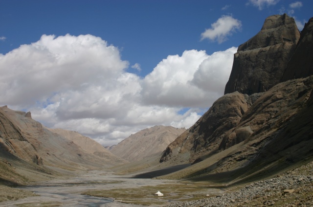
The kora starts at the charm-free village of Darchen, winding past mani walls and skirting the base of the Kailash massif. To the left, the huge, treeless Barkha plain is dotted with white nomadic tents and herds of sheep and goats.
At the first prostration point, the mountain's beautiful south face appears. The trail passes the famous Tarboche Flagpole and enters the extraordinary glacial Lha Chu valley, a flat, gravelly bottom receding between vast, sculpted red towers, broken crags and huge scree slopes.
Most trekkers will reach the Dira-Puk campsite at around 5,000m by mid-afternoon. Soaring, resplendent, above it is the famous north face, some 1,700m of banded rock and ice.
The second day trudges painfully through rough high valleys, past the Shiwa-tsal charnel ground, where pilgrims undergo a symbolic death, leaving an item of clothing (or hair, teeth or blood) to represent their renounced life, to the Drmla-la pass, festooned in prayer flags, at some 5,630m.
The kora then drops steeply past a turquoise sacred lake to a long, beautiful valley. Most hikers have a pleasant trudge in thickening air down to a campsite at the heavily grazed meadow of Zutul Puk, below a recently rebuilt monastery. They walk out into the open plain and back to Darchen the following morning.

From http://www.lib.utexas.edu/maps/middle_east_and_asia/asia_ref04.pdf


William Mackesy's account of this walk
Deep in the wilds of Western Tibet towers, in its majesty, Mount Kailash, sacred to four religions and a place of pilgrimage for centuries. At 6,714 m (a bit over 22,000 ft), Kailash does not rival the Himalayan giants, but it is a truly beautiful mountain, with its four striated faces under a cone of pure, unsullied snow.
Hindus and Buddhists believe Kailash.....

Other accounts and travel writing
Your comments on this walk, your experiences and suggestions, and your photos are very welcome. Where appropriate, you will be credited for your contribution.
Read about our travel writing and other competitions.
Practical information
See also expedition planning, including our universal expedition checklist. Walkopedia encourages responsible travel.
Books and maps
Books on this walk
Tibet Handbook (Footprint)– Gyurme Dorje
Mount Kailash Trek - Cicerone
Other books
A Mountain in Tibet – Charles Allen
Circling the Sacred Mountain – Robert Thurmann and Tad Wise
Kailas Mansarovar – Swami Pranavanda (out of print)
Maps
Various maps can be bought in Kathmandu, Lhasa or elsewhere, although the map in the Lonely Planet guide is perfectly sufficient for most walkers, as the path is so well trodden.
Best times to visit/weather
Best times to visit
Late May – early October
Weather
High mountains, so very variable, can snow in summer.
Getting there/transport/permits
Most people drive to Kailash from Lhasa or Kathmandu. There is no public transport. The majority hire jeeps and drivers in Lhasa (or join organised expeditions); some hitchhike, although this is very unreliable.
It is possible to hike in up the Humla valley and across the Himalaya from Nepal.
Route(s)
The kora is a well-trodden clockwise path around the mountain. Unless in snow, it is fairly hard to miss it.
Possible problems, health, other warnings
- Altitude: potentially fatal. Come prepared.
- Extreme mountain weather: snow, rain, severe cold are possible at any time of year.
- Heat and strong sun. Carry enough water and protect yourself.
- This is remote country: you will have to carry all your food and other supplies and help will be hard to get if things go wrong.
- Health risks: this is a relatively undeveloped country, and you will not get prompt medical help of a standard available elsewhere if you become ill. Come prepared.
- The authorities don’t take kindly to political action. You will imperil those around you as well as yourself.
See also the websites in out useful links page for more detailed, and up-to-date, information.
Safety and problems: All walks have inherent risks and potential problems, and many of the walks featured on this website involve significant risks, dangers and problems. Problems of any sort can arise on any walk. This website does not purport to identify any (or all) actual or potential risks, dangers and problems that may relate to any particular walk. Any person who is considering undertaking this walk should do careful research and make their own assessment of the risks, dangers and possible problems involved. They should also read “Important” for further important information.
Guided or independent?
Independent
It is possible to walk the kora independently, carrying tents or sleeping in the small, very basic guesthouses. Given the altitude, this is a tough option and needs careful planning.
Guided/supported
You can hire a guide and yak/ponies at Darchen, although this will not be a straightforward matter for most travellers, not least because of communication issues. There are many firms which will organise expeditions to/round Mt Kailash, which does take a lot of difficulties (including communication problems) out of the trip.
We walked in across the Himalaya and used Great Walks of the World (www.greatwalks.net/) to organise the expedition.
nd ahve a look at: https://www.yowangdu.com/
Accommodation
In Darchen (the start point): basic, limited and unpleasant. On the mountain: very basic, very limited and unpleasant. Camping is likely to be preferable.
Other things to do in the area
Other walks
Walk around the sacred Lake Mansarovar.
Walk up the Humla Valley, crossing the Himalaya from Nepal into Tibet.
Other activities
Two days' drive takes you to Tsaparang, the capital of the ancient Buddhist Guge Kingdom, a crumbling city of mud brick on a spike deep inside the upper Sutlej canyon.
COMMUNITY COMMENTS AND PHOTOS
Name: Bigboots
Posted on: 01/05/2008
Shattering, but splediferous. Just hope it doesnt get too commercialized as they build new roads, hotel etc.
Name: Doug
Posted on: 08/10/2011
Last year my wife and I walked the Mt Kailash kora and agree that it was then the number 1 wilderness walk. We have just returned from walking the kora again but sadly it no longer qualifies for even the top 100 in our opinion.
The Chinese have constructed a gravel road at least 2/3 of the way round the kora and there is, among some of the local Tibetans, a fear that the road may be extended completely round the kora. Not only does this road allow vehicle access to the most wild parts of the walk it has also destroyed some of the sacred areas along the walk. Perhaps most importantly - long sections of the pilgrim path has been torn up and replaced by the gravel road.
Some local opinion suggests this is a means by which the kora can be opened up to large numbers of Han Chinese tourists travelling in cars but also allows greater tourist access by the large number of Hindu tourists from India who come to the area often very poorly acclimatised.
Name: William
Posted on: 22/02/2013
The track they are building round the nountain sounds alarming for the integrity of the place. Please take care: this isn't disneyland!
Name: Adam A
Posted on: 28/05/2018
Looking for inspiration.
Add your experiences, suggestions and photos. We would be delighted to receive your writing and ideas (which will be attributed appropriately where published).
See our Fun page for some entertainment and to read about our travel writing and other competitions.
Anyone planning an expedition to this place should see further important information about this walk.
Responsible travel matters, a lot. How you travel will make a real difference - for better or worse. PLEASE consider this when making plans. Read more
 |