June 2010


We hope you find it inspiring and fun.

Let us know what you think and please tell a friend by forwarding this magazine to them.

If you would like to receive future editions, register here (it is easy). Coming up soon:
                        - Norway’s fabulous Lofoten Islands
                        - The Banaue Rice Terraces in the Philippines


www.walkopedia.net


Mount Kinabalu, Malaysian Borneo

Borneo slumbering at dawn


Mount Kinabalu stands, at 4,095m, in magnificent isolation above the Borneo jungle. Its top is a vast platform, formed relatively recently from volcanic upheaval and still growing, from which jagged peaks and pinnacles soar. Its upper slopes consist of several thousand feet of smooth precipice.

This is a steep, demanding walk with altitude gained more quickly than is advisable. The top is cloud-girt for much of most days: it is a dangerous and gloomy place once enveloped.

The climb starts at around 1,500m above the National Park’s pretty headquarters. The path winds, for the first kilometre, pleasantly around the hillside through thick forest and past the pretty Carson Waterfall, before turning onto the first staircase, which disaapears ominously into the trees far above. From here it is several hours of dreary, painful slog to the Laban Rata hut, where a short night will be spent before the pre-dawn assault on the peak.

Pitcher plant
Sunset


The trail follows long ridges up through a succession of very different vegetation zones. The mountain is a World Heritage Site, partly because of its magnificent botanical diversity. It is estimated to harbour up to 6,000 plant species, (including over 800 species of orchid, over 600 species of ferns, of which 50 are endemic) and has the world’s richest selection of carnivorous pitcher plants. You will trudge through cloud forests of moss-covered trees, past pink-flowering rhododendrons, straight trunked, parasite-infested trees, ferns and azaleas. Gradually, the soil turns redder and shrub-heather takes over.

The Laban Rata hut is remarkably pleasant, considering it feeds and sleeps so many people and sits on an inaccessible ledge at 3,300m.

Laban Rata, cliffs behind
Assisted section above Laban Rata


You will start early for the pre-dawn assault on the peak. The 750 plus metres up from the hut to the plateau at the top is fairly miserable, a very steep, tough slog, the altitude and yesterday’s exertions making every step an effort. Some steep scrambles up ropes on near-vertical rock give a degree of light relief. Finally, though, you reach the great cracked dome, and things got a lot better.

You will see great peaks and pinnacles silhouetted against the pre-dawn sky. The rim of the infamous Low’s Gully is just below the final Low’s Peak, a fearsome chasm dropping thousands of sheer feet into thick gloom.

Dawn sihouettes
Off the summit plateau

The western view from Low’s Peak is miraculous: far below, the shadow of the mountain visibly retreats back towards you across the clouds as the sun comes up. All around are the sharp, eroded pinnacles of the lesser peaks, the misty lowlands slumbering far below. Despite all the pain, it is worth it.

The descent, 2,500m to get down in one go, certainly isn’t much fun.

First light, mountain's shadow behind

TOP


Icon: from Hussaini, north of Hunza, Pakistan


Tilling with a view: looking north up the Hunza River valley to a famous formation of the high Karakoram.


Walkopedia rating:
92
More information on this walk

TOP


Walkopedia favourite: Hadrian’s Wall, UK

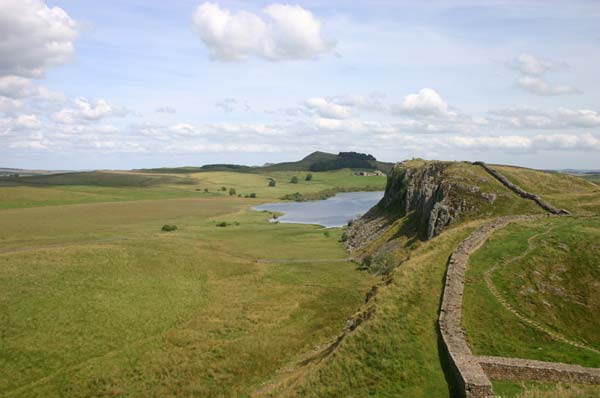
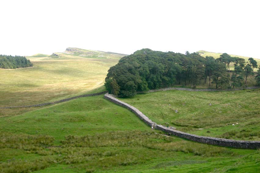
A classic view, Highshields Crag

It is hard to filter the information and images that well up when you try to explain Hadrian’s Wall’s fascination. It is one of Walkopedia's highest-ranking walks. Where to start?

Roman Britain's northern frontier had long been troublesome, with constant low-level fighting with the barbarian Picts to the north. By 122AD, the Empire was close to overstretch and the emperor Hadrian decided to withdraw from the Antonine Wall in the Scottish lowlands, building a strong permanent frontier along the hills and crags to the north of the Tyne valley. The wall ran for some 76 miles between Newcastle and the Solway Firth, the majority of it stone some four meters (14 feet) high with deep vallums (ditches) on each side. It was, amazingly, completed within sixteen years (some say less).

There were mile castles every Roman mile and regular forts, such as Housteads and Chesters, along the wall, with big camps such as Vindolanda a few miles behind.

The wall is in very mixed condition: some stretches, for instance Housteads to Steel Rigg, are in fantastic condition (actually, restored in the nineteenth century) and are deeply evocative. Other sections are almost invisible.

The wall survived well for some 1,000 years, 700 of them after its abandonment by the Romans, but was then pillaged for building materials until the twentieth century. The antiquarian John Claydon, who lived in the area, effectively saved much of what is left. In 1987, a central section – from Housteads to Chesters – became a World Heritage Site.

East from Housteads
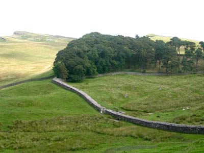
Toward Housteads from Hotbank Crags


The wall runs through magnificent scenery in many places, snaking along a series of volcanic rock ridges with extensive views across hill farms, moorland and lakes. The combination of extraordinary history and great natural beauty makes for thrilling, inspirational walking on the best sections.

Here are our notes on walking from the fort at Housteads westward along the high ridges to the road at Steel Rigg, possibly the best known and most walked section, but splendid nonetheless. While its scenery may not match the Himalayan, and it was a bit overpopulated the day I was there, it was captivating: gorgeous, wide views out from abrupt cliff-faces over the high farmland, moors and small lakes to the north and across the Tyne valley to the Pennine hills to the south; and an area redolent of extreme history.

The wall was brilliantly sited here, marching along a series of ridges, known as Whin Sill, the result of a hard igneous dolerite sheet having pushed up through the area's predominant limestone. These ridges break up into cliffs and tough slopes to the north, and you can see why the defensive line was moved northward here from the gentler banks of the Tyne.

Highshields Crag Rowan
Weed on Crag Lough


Beginning at the sprawling remains of the Housteads fort, and a sandwich munched on the wall, gazing northward to the land of the Pictish barbarians, I struck westward, along the only section of wall you are allowed to walk on, in pine and beech woodland above sheer cliffs to the north. While there is now doubt about whether the wall was regularly patrolled, there is an intense connectedness about striding along the actual wall, overlooking the rough hill farms to the north through sturdy pine trunks.

Shortly after the wood’s end, I was inspecting Milecastle 37, with its broken arch framing a fine view to the north. This is a gorgeous stretch, snaking along Hotbank Crags, dropping in and out of steep little notches. The wall is particularly charming and fascinating here, its even sides and grassy top evidence of their reconstruction under John Clayton in the 19th Century. Ersatz they may be, but they speak vividly of how the wall must have been.

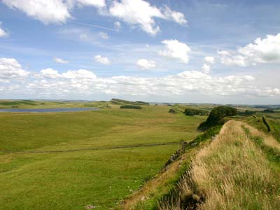
At the end of these crags is the famous Crag Lough, huddled below the dramatic Highshields Crags to its south, with the wall receding along precipitous ridges to the western skyline. Down toward the lake are the banked remains of Milecastle 38 and a fine stretch of the vallum (great defensive ditch) that ran parallel to the wall on its north side.

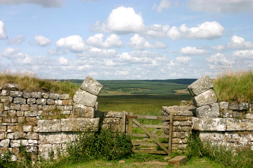
Through milecastle gate


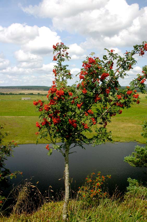
The mixed woodland and then open rocks above Highshields Crags are particularly memorable, with their views over the lough a couple of hundred sheer feet below. The rowans were bursting with the brightest red berries – almost a Platonic ideal of redness - when I was there.

Beyond Highshields, the wall drops to one of Britain’s more remarkable trees, a magnificent sycamore that seems to touch both sides of the steep little notch that is Sycamore Gap. It was apparently made famous in a film I never saw.

After a steep pant back onto the ridge, you wind around the cliff face, passing the remnants of another milecastle and enjoying perhaps the walk’s most famous view, back toward Crag Lough beneath the obdurate mass of the Highshield Crag.

Then a very steep dip indeed – how they managed to build (and operate) the wall in this terrain is sharply reminiscent of the outlandishly confident construction of the wall’s great counterpart, the Great Wall of China.

One more hillside – a steady trudge up close-cropped sward for a change – gets you to the roadhead at Steel Rigg.

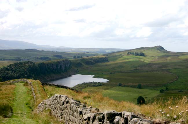
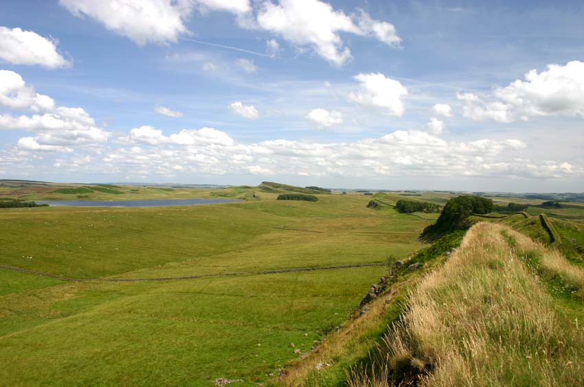
Crag Lough from the east


Walkopedia rating:
92
More information on this walk

TOP


Photo essay: Mount Athos, Greece

Along the peninsula from Mt Athos


South coast vegetation
Grand Lavra


Grand Lavra refectory
Mt Athos, above Panaghias


Toward Agia Anna
Grigoriou


Grigoriou quay
Dionysiou from the ferry


West coast path


Walking between monasteries on sacred, remote Mount Athos, the eastern arm of Greece’s Halkidiki Peninsula.


Walkopedia rating:
90
More information on this walk

TOP


Walking Interludes

You may be in an area only briefly. Here are some unmissable walks, all a day or less.

Tiger Leaping Gorge, ©Olivia Packe

Tiger Leaping Gorge, Yunnan, China

An extraordinary gorge carved by the wild upper Yangtse as it crashes off the Tibetan plateau. Follow an ancient goat track carved into the cliffs high above the tumultuous river, where huge logs look like matchsticks.

Walkopedia rating: 91
More information on this walk


Cinque terre ©flicr user Rob_Inh00d

Cinque Terre, Liguria, Italy

Walk the ‘High Trail’ on old pilgrimage and trade paths through the hills behind a group of five tiny sea-towns, each unique in personality, strung along Italy’s Ligurian Riviera. Scenery that swings between the picturesque and the spectacular in this UNESCO World Heritage area.

Walkopedia rating: 90
More information on this walk

TOP


New on Walkopedia website:


Walk of the month:

Latest walk:

 
Caldera de Taburiente, La Palma

Banaue Rice Terraces


  • An astonishing collapsed volcanic caldera which has produced a vast horseshoe of cliffs, rising approaching 2,000m from the caldera bottom to the rim.
  • Superb walk with huge views over the crags and chasms of the caldera, down to the distant sea in one direction, and down through the forests of the flanks of the ancient volcano in the other.
 
  • Ancient rice terraces, dotted with villages, hewn out of the mountainsides of Luzon's northern Cordillera. A deserved World Heritage Site.
  • Beautiful and fascinating walking along the rims of these terraces, some of which cling for hundreds of feet to the steep hillsides, and through the mountain forests that link the terraced areas.
  • This is a serious expedition - 7 to 10 hours getting there from Manila - so allow 4 days minimum.
 

Number of walks featured in Walkopedia:
350
Walkopedia use the magnificent Cicerone guidebooks
www.cicerone.co.uk


We welcome your recommendations and comments. Give us your thoughts.

Enjoyed this magazine? Forward it to a friend!

If you would like to receive future editions of our Walkopedia Magazine, register here (it is easy).


About Walkopedia Magazine:

Editors: William and Alexandra Mackesy

Contact us at walkopedia@googlemail.com. The Walkopedia website is at www.walkopedia.net.

We hope you enjoy our magazine. But we don’t want to waste your time, so feel free to unsubscribe at any time.

See Walkopedia's privacy policy


All materials © Walkopedia Ltd 2009, save where otherwise attributed.

TOP