 |
|

Welcome to the third edition of our Walkopedia Magazine. We hope you find it inspiring and entertaining.
If you would like to receive future editions, register here (it is easy). Coming up soon:
- Italy's fabulous Dolomites.
- Torajaland, Sulawesi

|
The World’s Best Walk? Mt Kailash Kora, Tibet
 |
|
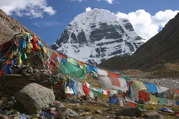
Majestic Mount Kailash, sacred to four religions and a place of pilgrimage for centuries, dominates the wilds of western Tibet. At 6,714 m (a bit over 22,000 ft), Kailash does not rival the Himalayan giants, but it is a truly beautiful mountain, with its four striated faces under a cone of pure, unsullied snow.
Hindus and Buddhists believe Kailash to be the navel, or axis, of the world and the abode of their Gods. Jains and followers of Bön, the ancient shamanistic religion of Tibet, also revere the mountain. Four great rivers issue from this region: the Indus to the north; the Yarlung Tsangpo to the east; the Sutlej to the west and the Karnali, older than the Himalayas themselves, southward.
Even before the Communist invasion of Tibet, few westerners had seen Kailash, although it has fascinated geographers and adventurers for more than two centuries. For nearly 40 years after the Chinese takeover, it was completely inaccessible. From the mid-1980s, foreigners have been allowed into Tibet, but Kailash’s extreme inaccessibility in the vast, nearly roadless wastes of the far west has contributed to its continuing mystique; even now, while much has been written about Kailash, few westerners have had the fortune to get there.
The destruction during the Cultural Revolution was desperate here, with hundreds of monasteries and shrines dynamited. The Chinese have since started to allow some reconstruction, and the fervour with which these dirt-poor people have rebuilt their sacred sites is profoundly moving.
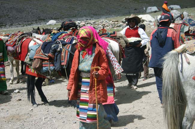
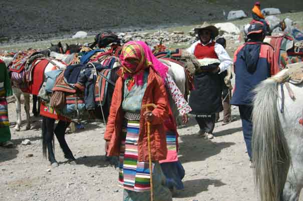
Pilgrims now throng to Kailash: not just Tibetans, but Hindus and Buddhists from India to Japan, joined by Western and Chinese travellers. Some walk across the Himalaya along old trade or pilgrimage routes, gaining valuable acclimatisation to the potentially fatal altitude.
Everyone comes to Kailash to walk the kora, the sacred circuit around the mountain. Every Tibetan aspires to walk the kora, as a lifetime’s sins can thus be washed away. Sharing the path with these pilgrims, often the simplest illiterate nomads who have saved for years to make the trip, is inspiring, whether or not you are a believer.
The kora is, by Walkopedia’s measures, the World’s best walk, an untouchable combination of beauty and drama, strange people and spiritual exaltation – despite the altitude-induced miasma you will walk in.
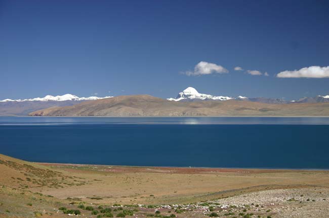
The kora starts at the charm-free village of Darchen, winding past mani walls and skirting the base of the Kailash massif. To the left, the huge, treeless Barkha plain is dotted with white nomadic tents and herds of sheep and goats. A corner of Rakshas Tal, the Demon Lake, shimmers in the distance beneath the gorgeous snowy mass of 7,728m (26,000 ft) Gurla Mandhata.
 |
|
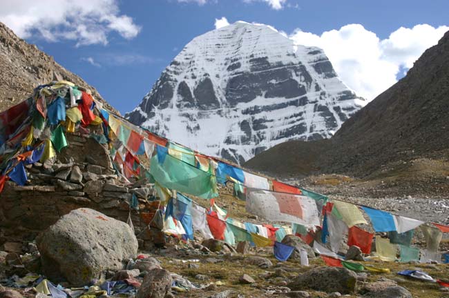
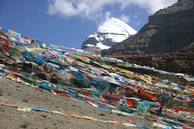
At the first prostration point, the mountain’s beautiful south face appears. The kora then turns north across a close-cropped tablecloth towards the famous Tarboche Flagpole, which is festooned with as many prayer-flags as I have seen anywhere - and in Tibet, that is saying something. On a shelf high above is an ancient sky burial site, around which huge lammergeyers soar on the thermals, and above that, much closer now, is the great white peak itself in all its perfection.
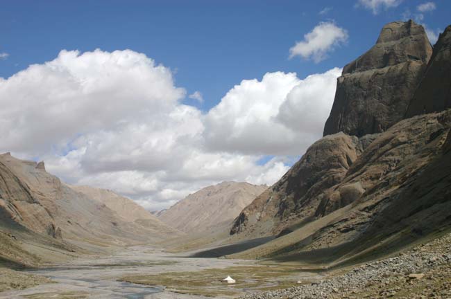
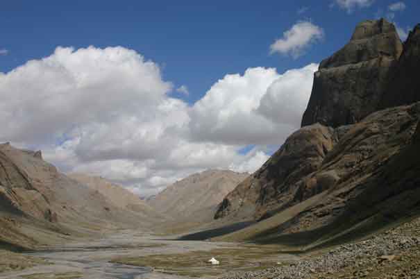
The trail follows the extraordinary, glacial Lha Chu valley. A flat, gravelly bottom recedes between vast, sculpted red towers of Kailash’s western flank, and broken crags with huge scree slopes on the left. The valley narrows into a dramatic gorge, and starts to climb in earnest. The crags above are now spectacular wind-polished blocks. The valley finally opens up again, its flat bottom dotted with yak among the sparkling strands of the stream.
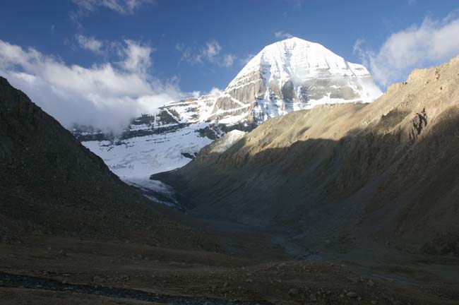
Another hour and a half’s labour, and you reach your campsite at around 5,000m (some 16,500ft), across the river from the tiny Dira-Puk monastery. Soaring resplendently to the south is the famous north face, some 1,700m (over 5,000 ft) of banded rock and ice.
|
|
From Tarboche flagpole, sky burial platform behind
|
Early morning light, from the north
|
The Day of the Big Test starts in the freezing pre-dawn. The kora crosses the Drömla Chu stream on some rickety poles and starts a long, gasping grind out of yesterday’s valley. Walking here quickly strips away millions of years of evolution: you are back to the primitive mechanics of life: a breath in or out with each slow step and frequent rests.
A steady flow of Tibetan pilgrims trudge past: thick sheepskin coats, edged with bright weavings, the top half hanging back from their belts as the day heats up; felt hats, prayer wheels, knives; the women in long, heavy skirts, their heads often shawled against the wind. They will have started from Darchen long before dawn. The men and women seem effortless as they march past; tiny, wizened grannies will keep your pace, if rather more cheerfully.
You will gain some respite as you enter the starkly beautiful upper valley. Another painful climb gets you to the Shiwa-tsal “charnel ground”, named after a famous place of cremation at Bodhgaya in India. Pilgrims undergo a symbolic death here, leaving an item of clothing (or hair, teeth or blood) to represent their renounced life. Across the valley, the fabled inner kora threads up a side valley, to cross a glacier and a high pass.
 |
|
Then it is the final agonising plod, lungs rasping in the thin air, 200m (650ft) up another heap of glacial boulders to the Drömla-la pass. The Drömla rock is swathed in prayer flags. Pilgrims clamber round the rock, under and over the ropes of flags that criss-cross the ground around the rock, chanting the invocation you hear at every pass in Tibet.
You will now be descending, first to the Pool of Great Compassion, in a bowl scooped from the shattered crags by some long-vanished glacier. There is no vegetation here, just vast, smashed boulders and the milky turquoise lake.
Another steep clamber gets you down into the long, beautiful Lham Chu valley, whose river gurgles, often in multiple strands, through patches of close-cropped grass and smooth boulders. It is perfect walking. Rounding a corner, you will gaze down on the beautiful, heavily grazed meadow of Zutul Puk, below a recently rebuilt but already dingy monastery. Most people spend their second night in this area.
The lower valley becomes drier, narrowing to a spectacular gorge of purple and green rock before debouching into the vastness of the Barkha plain.
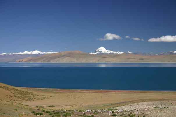 |
Kailash from across the Demon Lake
|
|
|
|
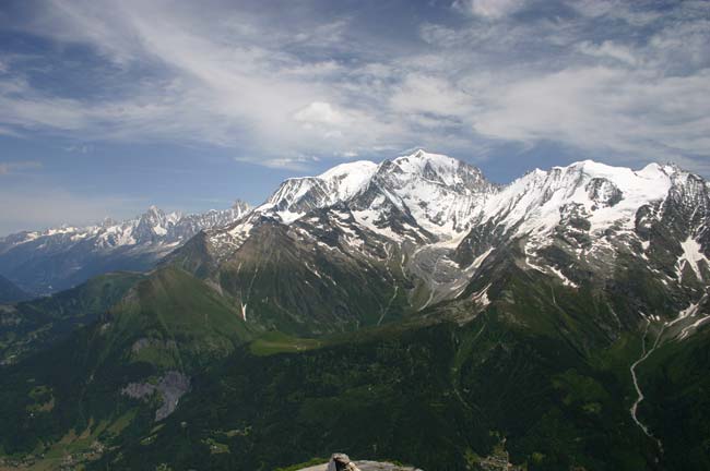
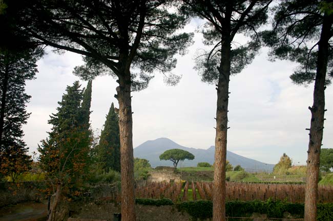
Icon: Mont Blanc from Mont Joly
|
|
|
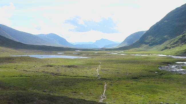
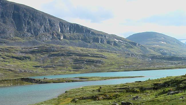
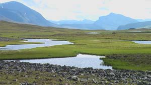
Walkopedia favourite: The Kungsleden, Sweden
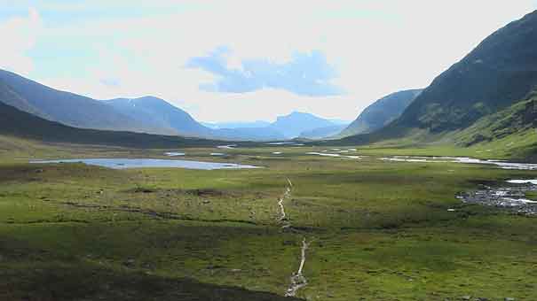 |
Fantastic Tjakjavagge valley
|
The Kungsleden (the king of trails), Sweden’s most famous long-distance path, winds for some 440km (275 miles) along the spine of Scandinavia in wild, remote Lapland. The trail runs through an enormous area, said to be Western Europe’s last major wilderness, passing through a World Heritage Site, four national parks and a nature reserve.
The Kungsleden is well inside the Arctic Circle, so is under deep snow for eight dark months. The walking season is short: if you want to avoid the horrors of the mosquitoes, it is just August to mid September. In late winter, there is a good window for skiing the route; dog sledding is also popular. In mid summer, you can see the midnight sun; when we were there in August, I could wander at 2am without a torch.
Life here is adapted to the extreme weather. In the lower valleys you pass through pretty, but at times monotonous, forests of stunted birch and rowan with patches of dwarf willow, fern and willow herb. Higher up, the plant life is still remarkably vigorous and beautiful: ground-hugging shrubs, bilberries to match the best Scottish hillsides, vivid patches of reed, a wide range of bog plants and pretty, delicate alpine flowers. Intermittent patches of grass sustain large herds of reindeer.
As well as reindeer, you may also see majestic elk, the famous (but normally unremarkable) lemmings and a wide variety of birds. Wolverines and brown bear are also to be found.
The indigenous Sami people, sometimes called Lapps, are nomadic herders in these high hills. You will come across their villages of red-painted cabins and traditional tepees and turf-covered huts by lakes and rivers, winter pounds for their semi-domesticated reindeer nearby.
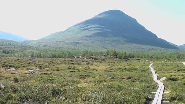 |
Approaching the high land
|
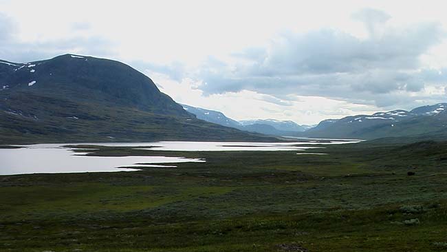
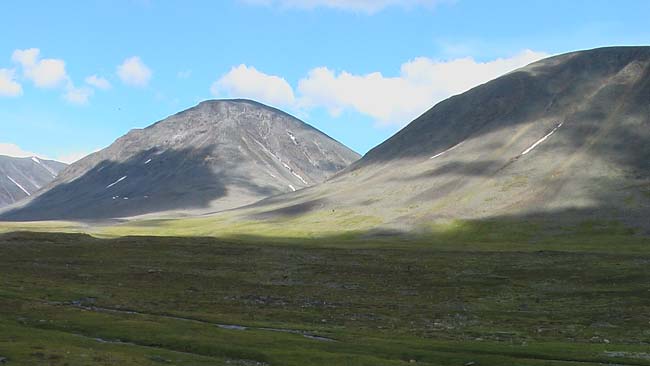
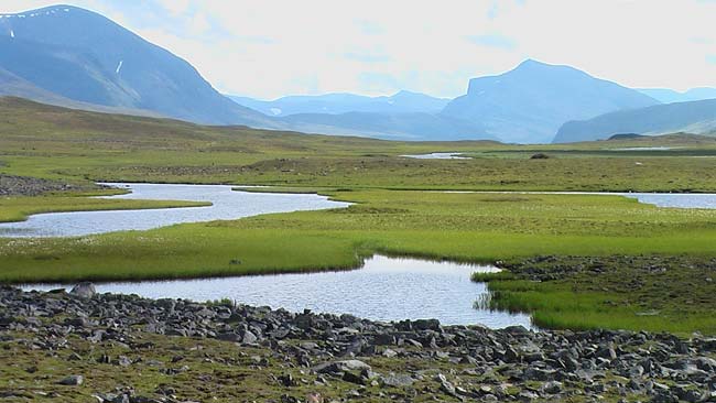
The Kungsleden officially runs from south to north, although the great majority tend to walk it southward. The trail’s most popular section, passing through possibly the finest scenery, is its northernmost one, starting at Abisko on the vast Lake Torneträsk. This section takes around seven days, to a roadhead at Nikkaluokta, the last two days being technically off the Kungsleden. It climbs up two beautiful valleys for three days, then spends two days in the vast, wild, beautiful Tjäkjavagge valley, which bisects the highest mountains in Sweden.
These hills are partly composed of ancient Caledonian granite, and are geologically related to the highlands of Scotland and the Appalachians in the USA. More recently, the area was under a vast ice-sheet up to two kilometres thick, which gouged out the extraordinary scenery that walkers now enjoy: huge U-shaped valleys lined with sheer cliffs, waterfalls roaring out of higher, hanging valleys along their sides. Lakes fill every scrape-hole and powerful rivers, some milky from their glacial sources, wind, often in multiple channels, along the boggy valley bottoms.
Everything is in such good proportion here – the high sides matched by the wide valley bottoms – that it is easy to underestimate the grand scale: it can take tiny human or reindeer figures, or surveying your last hour’s walk, to refocus your perceptions. The scale of the scenery, combined with steady progress with a heavy pack (and poor weather possibly inhibiting breaks to enjoy the scenery) can make, at times, for a disappointing “trudge to experience” ratio.
The Kungsleden is well constructed, with bridges where needed – there are plenty of large, potentially dangerous rivers to cross. There are comfortable huts at the end of each stage, which cannot be booked but never turn people away, so latecomers during peak season may have to sleep on mattresses on the floor. Gas and cooking implements are supplied, and the majority sell basic food. As a result, you do not need to carry a tent, cooker, or much food.
Other sections of the Kungsleden also make superb trekking, and are emptier of walkers, one section not having huts so requiring full backcountry procedures. Some lakes have to be crossed by rowing boat.
Section 3, going south (Saltoluokta to Kvikkjokk) is particularly fine, at the edge of the wild Sarek National Park. There are good side trips here, and the Padjelantaleden trail links up at both ends. The final stage, in the Vindelälvens Reserve, is also very beautiful, with lusher scenery than in the far north.
The highlights are probably the second and fourth days.
The second stage starts with a steady trudge into a side valley through thinning birch forest interspersed with bog and heath. Big views of the peaks and icefields on the Norwegian border open up to the west as you climb above the treeline. After passing some Sami huts on a plain, backdropped by rocky spines pushing up through a huge icecap just inside Norway, the trail emerges to a wonderful panorama of lakes and craggy mountains with small glaciers nestled high on their northern slopes. This is grand, wild, glorious country with a feel of Mongolia meeting Scotland. The trail heads up the broad Aliseatnu valley, past a series of lakes linked by a wide, shallow river. A 10km stretch of the valley appears as you crest a ridge, the winding river and many lakes a single sheet of brushed pewter in the arctic sun, offset by dark cliffs and mountains.
 |
 |
|
|
The fourth stage climbs steadily over broken stone to the Tjäktjapasset pass, the highest point on the Kungsleden at 1,140m, with a wonderful view down the upper reaches of the 32km Tjäkjavagge valley. It is a perfect specimen of a glacial valley, the river meandering, often many-channelled, through small marshes and lakes between heaps of moraine in its lush, boggy bottom. The mountains on each side have been carved, at intervals so regular that they look like they are on parade, by what once must have been subsidiary glaciers. Frequent waterfalls tumble out of the side valleys. The play of shadow on the long valley can be sublime.
The rest of the walk is a long, steady ramble along the valley, enjoying its many splendours, subtly arranged colourings and patches of delicate little flowers. The Sälka hut is perhaps the best positioned of all the huts we used, on an outcrop above a side river with views in both directions along the valley.
|
|
|
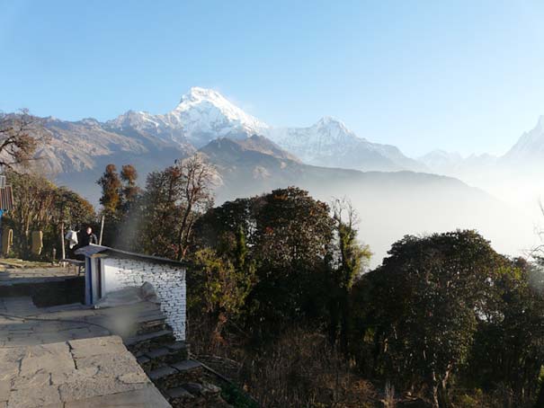
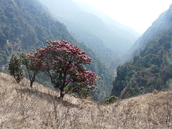
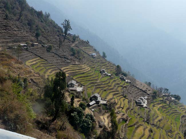
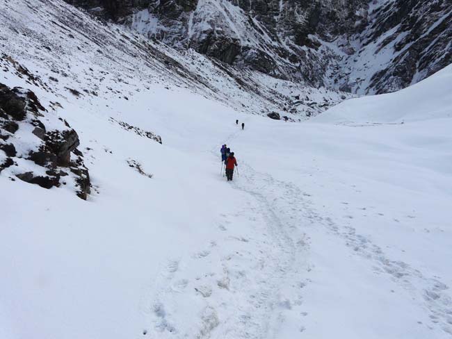
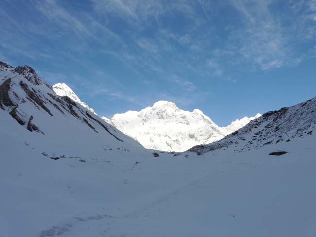
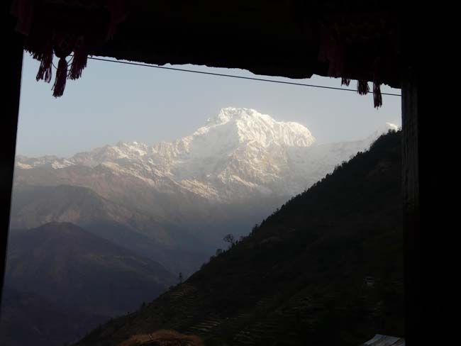
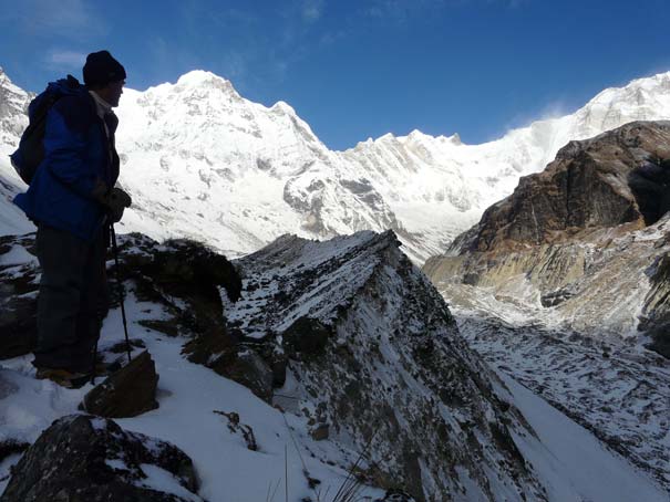
Photo essay: Winter at the Annapurna Sanctuary in winter
Walkopedia’s friend, Hong Kong Maestro Richard Winter, was under the Annapurnas in March ’09. Here are some of his pictures of this “winter” expedition.
|
|
|
En Passant: Philosopher King, Drakensberg Foothills
Our expedition was organised by the excellent Traverse Line, who were efficient, helpful and flexible to deal with and, we thought, good value. |
|
|
|
|
|
Walking interludes
You may be in an area only briefly. Here are some unmissable walks, all a day or less.
|
|
|
New on Walkopedia website:
|
| |
Walk of the month: |
|
Latest walk: |
| |
Sentier Cathar France/Spain
|
|
|
| |
|
|
|
| |
- This track follows the trails between the strongholds of the Cathars, C13 heretics who were brutally suppressed by the Inquisition (which was formed for the purpose) in the foothills of the eastern Pyrenees, then follows an escape route across the mountains to Spain.
- Revel in beautiful scenery (mountains, meadows and gorges), improbable castles, enthralling (if tragic) history: eat superbly at the day's end.
- Wonderfully varied sections can be tackled individually to suit your taste from the meadows, castles and forests of the foothills to the crags, gorges and passes of the high Pyrenees.
|
|
-
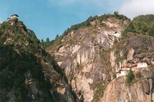
Famous walk to Taktshang Goempa (Tigers Nest), Bhutans best known (if not finest) and most dramatically situated monastery, clinging to cleft in a sheer cliff, 900m above the Paro valley. An inspiring walk to a tremendous place.
-
The initial trudge up the hillside, through scrubby trees but with increasingly fine views across the fertile valley toward the surrounding hills, can seem like a bit of a tedious slog, especially if you are newly arrived at this altitude, but the first glimpse of the monastery dispels all doubts.
-
The Lonely Planet has helpful information on this trek.
|
Number of walks featured in Walkopedia: 318.
|
|
|
 |
|